Region
Rhovanion
The wide wilderland east of the Misty Mountains, cut in two by the Great River Anduin
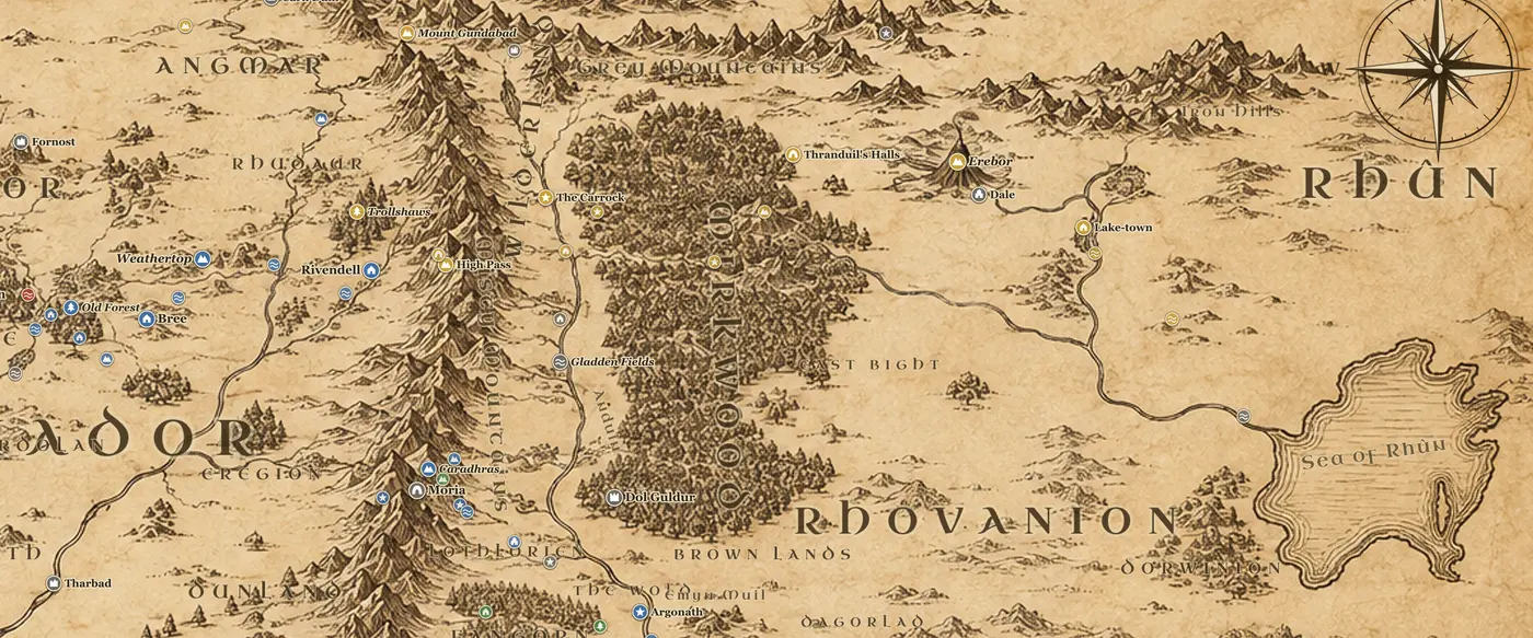
Rhovanion, often called Wilderland on maps of The Hobbit, is the whole eastern half of the northern map. It stretches from the foot of the Misty Mountains east past Mirkwood toward the Sea of Rhun, and from the Grey Mountains in the north down to the Brown Lands and the Emyn Muil in the south. The Great River Anduin runs through it from its springs in the Grey Mountains all the way south to Gondor, and the vales along its upper course are the most traveled part of the region.
Coming down out of the High Pass a traveler reaches the Carrock, a tall rock standing in the Anduin with steps cut into it, and a little north of that is Beorn's Hall, the house of the skin-changer who feeds Bilbo's company and later fights at the Battle of Five Armies. Downstream the river spreads into the Gladden Fields, a marsh of reeds and yellow iris where Isildur was killed by Orcs in TA 2, and where the One Ring lay in the riverbed until Deagol found it. The Stoors of the Gladden, the river-folk that Smeagol came from, lived near those banks.
Farther south, on the east side of the Anduin below the Dimrill Dale, lies Lothlorien, the Golden Wood of mallorn trees ruled by Celeborn and Galadriel, with Caras Galadhon as its city. Between Lothlorien and Mirkwood the open grassland once held the Kingdom of Rhovanion, whose people were kin to the Rohirrim. The Northmen were broken by the Wainriders in TA 1856, and the survivors drifted north and west. Framsburg on the upper Anduin remembers Fram, an ancestor of the Eotheod who killed the dragon Scatha. From these same people came the Eorlingas, who rode south in TA 2510 and were granted Rohan.
The Brown Lands on the eastern bank south of the Gladden Fields are a burned waste, ruined long ago in the war against Sauron, and the river carries travelers past them toward the Argonath.
In The Hobbit, Rhovanion is simply the road: Carrock, Beorn, Mirkwood, Lake-town, Erebor. In The Lord of the Rings the Fellowship crosses it by boat from Lothlorien down the Anduin, and the region becomes the hinge between the northern and southern halves of the story.
Frequently asked questions
Where is Rhovanion on the Middle-earth map?
Rhovanion is everything east of the Misty Mountains and north of Rohan and Mordor, reaching as far east as the Sea of Rhun. Mirkwood sits in the middle of it and the Anduin runs down its western side.
Is Rhovanion the same as Wilderland?
Yes. Wilderland is the name used on the map in The Hobbit for the same country that The Lord of the Rings calls Rhovanion.
Where is Lothlorien on the map?
Lothlorien lies on the east bank of the Anduin, just south and east of the Dimrill Dale where Moria's eastern gate opens, between the river and the Celebrant.
Where were the Gladden Fields?
Where the Gladden River joins the Anduin, some way south of the Carrock. Isildur was ambushed and killed there in TA 2, and the One Ring lay in the river nearby for almost 2,500 years.