Island · Gondor
Tolfalas
The rocky island in the Bay of Belfalas, off the mouths of Anduin
- Appears in
- The Lord of the Rings
- Region
- Gondor
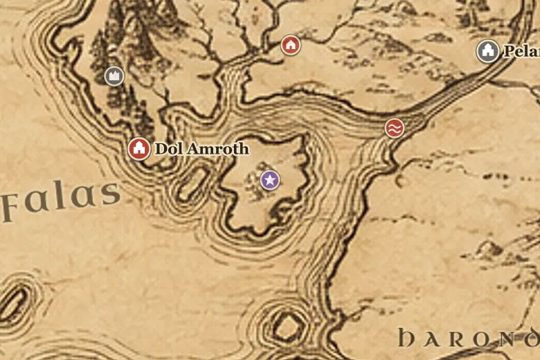
On the map Tolfalas sits offshore below Ethir Anduin, roughly between the cape of Dol Amroth to the west and the coast of Harondor to the east. Its name means Shore Isle.
The island stands where the river current meets the bay, and ships working between Umbar and the Anduin passed close to it. Gondor's charts marked it as a sea mark rather than a settlement, since there was nothing on it worth holding.
It is thought to be what survived of a larger piece of coast after the upheavals that followed the Downfall of Númenor in SA 3319, when the seas rose and the western shorelines were reshaped. In the Third Age it was left desolate, useful only for navigation.
Events at this place
-
SA 3319 · The Silmarillion
The coasts reshaped
The changes that followed the Downfall of Númenor altered the western shores, leaving Tolfalas as a bare island in the bay.
Frequently asked questions
Where is Tolfalas on the Middle-earth map?
In the Bay of Belfalas, south of the mouths of Anduin and southeast of the cape of Dol Amroth.
Did anyone live on Tolfalas?
No. It was a bare rocky island in the Third Age, used by sailors as a landmark rather than settled.