Region
The Shire
The green homeland of the hobbits, set in northwest Eriador between the Far Downs and the Brandywine
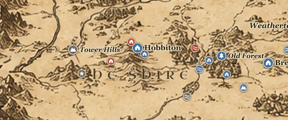
On the Middle-earth map the Shire is a small square of tilled green in the northwest of Eriador, north of the Great East Road and south of the Northern Moors. Tolkien gives its size as about forty leagues from the Far Downs in the west to the Brandywine Bridge in the east, and fifty from the moors in the north to the marshes in the south. The Brandywine River, the Baranduin in Elvish, makes the eastern boundary, and beyond it lie Buckland, the Old Forest and the Barrow-downs. To the west the land rises to the Far Downs and the Tower Hills, and past them the Grey Havens open on the Gulf of Lune.
The land is divided into four Farthings, North, South, East and West, with Buckland added east of the river and the Westmarch granted later by King Elessar. Michel Delving on the White Downs is the chief town and the seat of the Mayor. Hobbiton and Bywater sit near the center on the Water, with Bag End dug into the Hill above Hobbiton. Sarn Ford in the south is where the Brandywine can be crossed on foot, and Bucklebury Ferry carries travelers over to Crickhollow.
The Shire was granted in TA 1601 by Argeleb II of Arthedain to the brothers Marcho and Blanco, who led hobbits west from Bree. When the North-kingdom fell in TA 1974 the hobbits kept their own calendar, their Mayor and their Thain, and forgot that Rangers guarded the roads and fords for them.
Both of Tolkien's great tales begin here. In TA 2941 Bilbo Baggins is swept out of Bag End by Gandalf and Thorin's company. Sixty years later the Ring passes to Frodo, and in TA 3018 he sells Bag End and slips away east through Bucklebury Ferry. The story also ends here: in TA 3019 the returning hobbits find the Shire under Saruman's ruffians and break them at the Battle of Bywater on November 3.
When you look at this corner of the map, the places worth finding are Hobbiton and Bag End at the center, Bywater beside them, Michel Delving in the west, the Brandywine Bridge and Bucklebury Ferry in the east, Crickhollow in Buckland and Sarn Ford in the far south.
Frequently asked questions
Where is the Shire on the Middle-earth map?
The Shire is in the northwest of Eriador, west of the Brandywine River and roughly 120 miles west of Bree along the Great East Road. On most maps it is the small green region below the Northern Moors and east of the Tower Hills.
How big is the Shire?
Tolkien gives it as about forty leagues from the Far Downs to the Brandywine Bridge and fifty leagues from the northern moors to the southern marshes, which is roughly 120 by 150 miles.
What are the four Farthings of the Shire?
North, South, East and West Farthing. Buckland lies east of the Brandywine and is not a Farthing, and the Westmarch beyond the Far Downs was added in the Fourth Age.
Is Hobbiton the capital of the Shire?
No. Michel Delving on the White Downs is the chief town and the seat of the Mayor. Hobbiton is simply the village where Bag End stands.