Region
Eriador
The wide empty country between the Blue Mountains and the Misty Mountains, full of ruined kingdoms
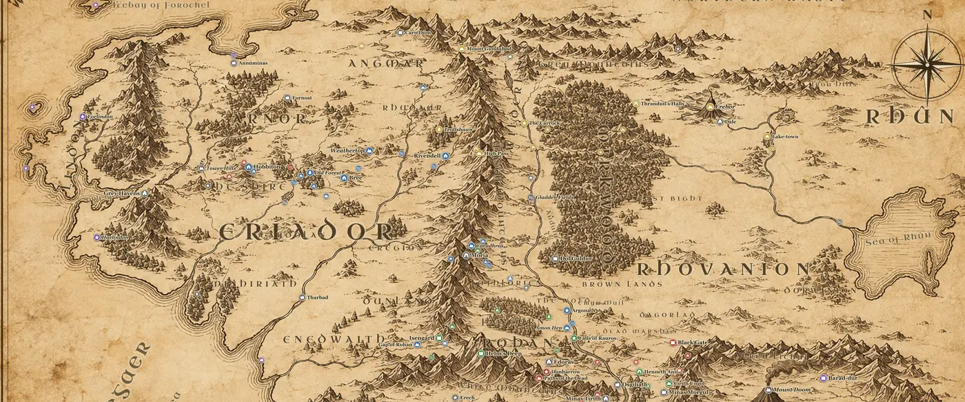
Eriador is the widest stretch of settled emptiness on the Middle-earth map. It runs from the Blue Mountains in the west to the Misty Mountains in the east, and from the frozen Ice Bay of Forochel in the north down to the Greyflood and the Gwathlo crossings in the south. The Shire and Lindon lie in its northwest corner, and beyond its southern edge the land runs on into Minhiriath, Enedwaith and Dunland. Two great roads cross it: the Great East Road from the Grey Havens through Bree to the Ford of Bruinen, and the North-South Road that once linked Fornost to Tharbad and on to Gondor.
The landmarks along the East Road are the spine of the region. East of the Brandywine the traveler passes the Old Forest and the Barrow-downs, then Bree under Bree-hill, then the Midgewater Marshes and the bare crown of Weathertop, where the tower of Amon Sul once stood. Further east the road crosses the Last Bridge, climbs through the broken country of the Trollshaws, and comes at last to the Ford of Bruinen and the hidden valley of Rivendell under the mountains.
This was Arnor, founded by Elendil in SA 3320. In TA 861 it split into Arthedain in the northwest, Cardolan in the south and Rhudaur in the east, and the three kingdoms wore each other out in wars with Angmar. Cardolan fell in TA 1409, Rhudaur became a client of the Witch-king, and Arthedain was destroyed in TA 1974 when Fornost was taken. Annuminas on Lake Evendim, the first capital, was already deserted long before that. What remains on the map by the end of the Third Age are ruins, and the Rangers who walk among them.
Eregion, on the western slopes of the Misty Mountains, has its own history. There the Elven-smiths of Celebrimbor made the Rings of Power in the Second Age, and there Sauron destroyed them in SA 1697. The Doors of Durin in Moria's western wall were the gate between Eregion and the Dwarves.
In the story Eriador is the long first act. Frodo and his companions cross almost the whole of it on the way to Rivendell, from the Old Forest and Tom Bombadil's house to Bree, Weathertop and the flight to the Ford.
Frequently asked questions
Where is Eriador on the Middle-earth map?
Eriador is the whole western third of the map north of the Greyflood, lying between the Blue Mountains and the Misty Mountains. The Shire, Bree and Rivendell are all inside it.
Is Eriador the same as Arnor?
No. Eriador is the geographic region. Arnor was the kingdom of Men founded there by Elendil, and it covered much but not all of Eriador before it broke apart in TA 861.
What towns are left in Eriador in The Lord of the Rings?
Very few. Bree and its neighbor villages are the only settlement of Men on the East Road, and the Shire is the only other populated land. Fornost, Annuminas and Tharbad are ruins.
How far is Bree from Rivendell?
About 300 miles by the Great East Road. Frodo's company left Bree on September 30, TA 3018 and reached Rivendell on October 24, taking a slower cross-country route.